Job Site (Region) Editing
Jump to navigation
Jump to search
__NOTITLE__
Job Site(Region) Editing
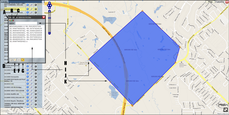
- Save Icon: Click to save changes to the region. This will close the editing session and the map will automatically update with the newly defined region. Saving will save changes to the polygon itself and the region's name. Note that if you change the textual description without clicking the apply button, the textual definition is saved and may not match what is displayed.
- Apply Icon: Used to update the editing object (shown in blue) on the map. This does not save the object, just updates the display to match the definition.
- Cancel Button: Closes the editing session without saving any changes.
- Navigation Control: Allows user to return to normal navigation mode without cancelling the editing session. This is useful if you want to pan or zoom then return to editing.
- Polygon Drawing Tool: When activated each click on the map will add a vertex, double-clicking will connect the current point to the first completing the polygon. On completion of drawing a polygon with this tool, the WKT syntax (A) will be updated to include the new polygon.
- Regular Polygon Drawing Tool: Similar to F but draws a regular polygon (equilateral triangle, square, pentagon, hexagon, etc.) with the specified number of sides. To specify the number of sides, hover over the control (defaults to 4).
- Editing Control: Only enabled once a polygon is present. Used to re-enter editing mode after using the navigation control. Click on this control then on your polygon to re-enable editing mode. Also used to set editing options. By default the editing mode is vertex mode, but by hovering over this control you may change the mode to any combination of scaling and rotation and dragging. To return to normal mode uncheck the rotation, scale and drag options.
- Region Name: To change the region's name simply change it here and save.
- The WKT (Well Known Text) Region Specification: A textual representation of the multipolygon object being edited. You may directly modify/define the region's definition here. If you do modify this definition you must press the apply button (C) for the visual representation to change on the map. A multipolygon is defined as list of polygons. A polygon is defined as a list of closed line strings; the first defines the polygon's outer perimeter and subsequent line-strings define holes inside that perimeter. A closed line string is a list of points where the first point is equal to the last (closed). Most regions will be simple multipolygons consisting of single polygons, consisting of single line strings.
- Vertex: Corresponds to a longitude/latitude pair in the WKT definition. In normal editing mode you can move vertices by simply dragging them.
- Edge: An unshaded handle is shown on every edge, if you drag this handle it will add a vertex to your polygon. Using this technique you can easily create very complex polygons.